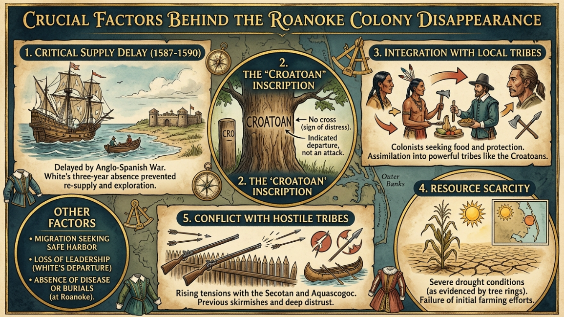
The 1590 vanishing of the English settlement on Roanoke Island remains an iconic puzzle in colonial archaeology. When Governor John White returned to the North Carolina coast after a three-year supply delay, he found the entire civilian population completely gone. The physical structures had been dismantled, and the single remaining trace was a cryptic word carved into a wooden palisade post. For centuries, popular historical analyses focused on romanticized theories of sudden violent slaughter or total supernatural erasure. However, modern archaeological data and environmental forensics have systematically reframed the mystery, stripping away the folklore to expose a brutal operational reality.
What makes the Roanoke colony disappearance a premier case study for historical forensic reviews is how resource limits leave distinct signatures in the physical landscape. By analyzing modern soil maps, tree-ring data grids, and local tribal movement records, researchers have shifted the case from an inexplicable anomaly to a logical, desperate evacuation event forced by ecological constraints.
1. Mega-Drought Chronology and Dendrochronological Evidence
The most definitive scientific breakthrough regarding the Roanoke colony disappearance emerged from the study of ancient tree rings, a discipline known as dendrochronology. In the late 1990s, climate scientists reconstructed the historical precipitation timelines for the southeastern United States by sampling core segments from thousand-year-old bald cypress trees located near the Roanoke basin.
The resulting data grids revealed a devastating environmental anomaly. The exact window between 1587 and 1589 marked the most severe, unmitigated mega-drought the region had experienced in nearly 800 years. This historic dry spell completely compromised the local agricultural capacity. The colonial settlers arrived at the absolute worst ecological moment possible, planting crops in sandy soil that was devoid of moisture.
Because the natural water tables collapsed, the surrounding vegetation died, and local wildlife migrated away from the coast to find active freshwater streams. The severe drought effectively placed a hard, immediate countdown on the colony’s baseline survival, rendering long-term residency on the barrier island physically impossible without external supply chains.
2. Soil Saturation Limits and Agricultural Architecture
To understand the tactical failure of the settlement, forensic archaeologists have meticulously mapped the soil profiles of Roanoke Island. The island’s geography consists primarily of dynamic maritime forest floor sand and poorly drained maritime wetlands. This specific soil architecture possesses an exceptionally low nutrient retention capacity.
European farming techniques of the 16th century relied heavily on consistent rainfall and rich, deep loam soils to cultivate wheat and barley. When the settlers attempted to replicate these farming structures on the sandy coastal fringe during a mega-drought, the failure was absolute. The porous sand allowed what little moisture fell to instantly drain straight into the subterranean brackish water layers, burning the root systems of the crops.
As their stored English provisions decayed, the colonists realized that the land itself was structurally incapable of supporting a fixed population of over one hundred individuals. This forced an immediate tactical choice: face starvation inside their wooden fort or abandon the physical structures to merge with mobile, highly adapted indigenous populations.
3. The Structural Mechanics of the Croatoan Carving
The physical condition of the abandoned settlement provides critical behavioral clues regarding the final hours of the colony. When John White inspected the site in August 1590, he recorded that the houses had been completely taken down, and the perimeter was enclosed by a high palisade of tree trunks. On one of the primary structural posts, the word “CROATOAN” was clearly carved into the wood.
In modern forensic tracking, the method of a structure’s dismantling tells you everything about the timeline of the departure. The houses were not burned, shattered, or left to rot in a chaotic panic, which would be the definitive taphonomic footprint of a hostile attack. Instead, they were carefully unbolted, unroofed, and disassembled piece by piece.
This deliberate structural architecture proves that the Roanoke colony disappearance was a planned, orderly relocation. The colonists packed up their heavy materials and moved to a pre-arranged destination. The carving on the post was a deliberate communication vector left behind to guide the delayed supply ships directly toward their new coordinates.
📊 Forensic Architecture and Ecological Breakdown Matrix
| Analytical Focus | Physical / Archaeological Footprint | Primary Environmental Implication | Structural Impact on the Colony |
| Tree-Ring Core Samples | Extreme narrow band clustering (1587–1589) | 800-year historical mega-drought anomaly | Total failure of baseline agricultural water supply |
| Soil Core Profiles | High-porosity maritime sand and brackish water | Instant nutrient leaching and crop root burnout | Eradication of self-sustaining food security models |
| Palisade Post Forensic Review | Uniform incision carvings; lack of carbon ash | Orderly, tool-assisted dismantling of houses | Confirms a planned, non-violent mass evacuation |
4. Tribal Relocation Trajectories and Isotope Tracking
The carved message pointed directly toward Croatoan Island (known today as Hatteras Island), located roughly 50 miles south of the original fort. This location was the ancestral home of the Hatteras Indians, an indigenous group that maintained a positive diplomatic alliance with the English.
Modern archaeological digs along the barrier islands have recovered distinct material anomalies that support this relocation vector. Excavations have unearthed 16th-century European items—including a specialized gold signet ring, English iron axes, and early glass beads—buried deep within historical tribal garbage heaps.
Furthermore, forensic isotope tracking of human remains found across eastern North Carolina indicates a blending of distinct genetic groups during this specific historical window. When a population shifts its geographic position due to famine, they naturally integrate into the socio-economic framework of the dominant local cultures. The physical artifacts discovered in the soil prove that the colonists did not vanish into thin air; they simply dissolved into the regional tribal networks to survive the crushing regional drought.
5. The Fatal Strategy of the Low-Resource Perimeter
The ultimate systemic failure behind the Roanoke colony disappearance was the initial strategy used to choose the site’s location. The settlement was intentionally positioned in a hidden, shallow coastal sound to protect the English ships from detection by hostile Spanish warships moving up the Atlantic coast.
While this choice provided exceptional operational security from military enemies, it created an unviable loop of isolation. The shallow waters prevented large deep-draft supply vessels from anchoring close to the beach, forcing treacherous small-boat transfers across shifting sandbars.
When England entered a total war footing against the Spanish Armada in 1588, all civilian shipping was permanently frozen. The Roanoke settlers were left entirely stranded in a low-resource perimeter with zero logistical fallback options. The combination of structural isolation, extreme drought, and the total cutoff of transatlantic support made the abandonment of Roanoke a structural certainty.
The Logistical Conclusion of the Roanoke Mystery
The fate of the lost colonists was never a supernatural occurrence or an inexplicable cosmic erasure. Through the clear lens of modern environmental science and soil forensics, the Roanoke colony disappearance resolves itself as a classic, rational survival migration.
Faced with a historic multi-year drought, sterile sandy soil, and complete logistical abandonment by their mother country, the settlers did the only logical thing left to do. They dismantled their settlement, carved their destination into the perimeter timber, and walked away from Roanoke to survive among the only people who knew how to tame the outer banks.